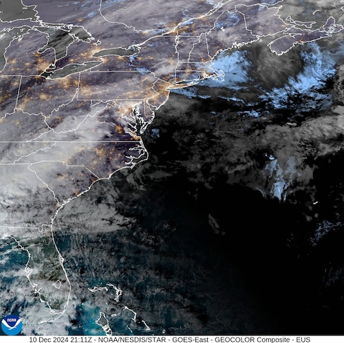
Maine’s Portland (AP) Due in part to an atmospheric river and a building bomb cyclone, the U.S. East Coast was starting a potentially dangerous, windy, and rainy stretch of weather on Wednesday that might cause whiplash.
In a single day, areas such as western Maine may see freezing rain, torrential downpours, abnormally high temperatures, and destructive winds, said to National Weather Service forecaster Derek Schroeter.
Forecasters warned that flooding may occur in some locations due to the intense rain and strong gusts that are expected to last until Wednesday night in various spots. In addition, utilities were preparing for possible power disruptions due to damage from gusts that could reach 60 mph (97 kph) in some places.
The National Weather Service predicts that temperatures in central Pennsylvania will reach over 56 degrees by 8 a.m., then drop to roughly 42 degrees during the day and grow windier. An further three-quarters to one inch of precipitation could fall.
The rain will eventually stop tonight, but the wind will still be strong, reaching gusts of up to 32 mph.
Thursday is predicted to be sunny with a high of around 34.
According to Schroeter, who is headquartered in Gray, Maine, an atmospheric river—a lengthy band of water vapor that can carry moisture from the tropics to more northern regions—is one of the main elements influencing the weather on the East Coast.
Because it has the capacity to draw moisture from the Atlantic Ocean off the southeast coast of the United States and carry it to states like Maine, the storm has the potential to have a significant impact on New England. According to Schroeter, the state was getting ready for a complex storm that would dump two to three inches of rain in some places.
On Tuesday night and into early Wednesday, the area had a mix of fog and light freezing rain.
According to Schroeter, as temperatures increase into the 50s (10–15 Celsius), we will be keeping an eye out for the possibility of flash flooding and sudden rises on streams.
Additionally, forecasters warned that the storm might involve a bomb cyclone, a process known to meteorologists as “bombogenesis.” That is the ability of a cyclone to intensify quickly and with the potential to generate heavy rainfall.
The Northeast was already bracing for severe weather.
The Presidential Range of mountains in New Hampshire, which saw heavy snowfall during the past two weeks, received a special bulletin from the Mount Washington Avalanche Center on Wednesday.
According to the report, heavy rains might produce hazardous and erratic avalanche conditions on steep snow-covered slopes, posing a risk to bridges, skiing and hiking paths, and stream crossings.
Tuesday started with a couple of inches of snow, and some schools in Maine were operating on a delay. From Wednesday afternoon until Thursday morning, Vermont is under a flood watch.
Residents in Montpelier, Vermont, were being advised by the city to elevate goods in basements and low locations that are susceptible to flooding and to prepare for mild flooding in the area. The city announced on Tuesday that it will be closely monitoring the river levels during this storm and has been in communication with Vermont Dam Safety and the National Weather Service.
On Wednesday, ski resorts in the Northeast were getting ready for what might be a stormy day. The southern Vermont resort, Stratton Mountain Resort, advised visitors to bring Gore-Tex clothing because the weather is expected to be wet.
Note: Every piece of content is rigorously reviewed by our team of experienced writers and editors to ensure its accuracy. Our writers use credible sources and adhere to strict fact-checking protocols to verify all claims and data before publication. If an error is identified, we promptly correct it and strive for transparency in all updates, feel free to reach out to us via email. We appreciate your trust and support!

